
NASA releases satellite imagery and data maps for LA County wildfires
NASA has released new satellite wildfire maps for Los Angeles County, providing detailed insights into burn areas, fire severity, and atmospheric impact.

NASA has released a comprehensive set of satellite maps and data visualizations to help analyze the impact of the recent wildfires in Los Angeles County. These maps provide crucial information about fire severity, burn scars, and atmospheric conditions, using data from multiple satellite sources, including Sentinel-1, Sentinel-2, VIIRS, and Landsat.
Multiple destructive fires are currently burning in the Los Angeles, California area.
— NASA Earth (@NASAEarth) January 8, 2025
As of Jan. 8, the blazes have destroyed thousands of structures and prompted officials to issue evacuation orders. @NASA’s Aqua satellite captured this image of smoke from the Palisades fire. pic.twitter.com/ozrOl2QCSm
This release comes as CAL FIRE reports that California has already experienced 398 wildland fires in 2025, burning 57,665 acres—a significant increase compared to past years. With this new satellite data, scientists, emergency responders, and the public can better understand the wildfire aftermath and ongoing environmental impact.
Available NASA Maps and Data Products
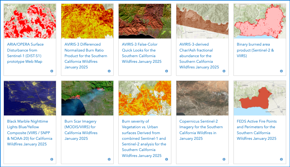
NASA has made the following maps available for public access:
Surface Disturbance and Damage Assessment
- ARIA/OPERA Surface Disturbance from Sentinel-1 (DIST-S1) prototype Web Map
- Sentinel-1 Likely Damaged Areas and Structures for the Southern California Wildfires January 2025
- OPERA Disturbance Alert from Harmonized Landsat Sentinel-2 (DIST-ALERT-HLS)
- Southern California Wildfires: Change Detection using Sentinel-1 VH RTC
Burn Area and Fire Severity Mapping
- AVIRIS-3 Differenced Normalized Burn Ratio Product for the Southern California Wildfires January 2025
- Binary Burned Area Product (Sentinel-2 & VIIRS)
- Burn Scar Imagery (MODIS/VIIRS) for California Wildfires January 2025
- Burn Severity of Vegetation vs. Urban Surfaces (Sentinel-1 & Sentinel-2)
- Sentinel-2 Normalized Burn Ratio Difference (dNBR)
- OptiSAR-based Enhanced Fire Severity Classification
High-Resolution Fire Imagery
- AVIRIS-3 False-Color Quick Looks for the Southern California Wildfires January 2025
- AVIRIS-3-derived Char/Ash Fractional Abundance
- Copernicus Sentinel-2 Imagery for the Southern California Wildfires January 2025
- Landsat Imagery for the Southern California Wildfires January 2025
- True Color Imagery (Planet) for Southern California Wildfires January 2025
Active Fire Monitoring and Perimeters
- FEDS Active Fire Points and Perimeters for the Southern California Wildfires January 2025
- Black Marble Nighttime Lights Blue/Yellow Composite (VIIRS / SNPP & NOAA-20)
Air Quality and Atmospheric Impact
- TEMPO Nitrogen Dioxide (NO2) Vertical Column for the California Wildfires January 2025
- Tropospheric Emissions: Monitoring of Pollution (TEMPO) Version 03 Level 3 Gridded Formaldehyde (HCHO) Vertical Column
- Land Surface Temperature from ECOSTRESS for January 2025 California Wildfires
Additional NASA Observations
- International Space Station Images of Southern California Wildfires: January 10, 2025
- Principle Component Analysis of AVIRIS-3 High-Resolution Spectral Reflectance
These maps will assist fire agencies, researchers, and policymakers in assessing fire damage, tracking regrowth, and planning for future wildfire prevention. They also provide a real-time look at how wildfires impact air quality and land surface conditions across California.
For those interested in viewing these NASA wildfire maps, they are accessible through NASA’s online wildfire data portal.
Why This Matters
The release of these detailed wildfire maps aligns with the growing need for high-quality satellite imagery to monitor climate-driven disasters. The increase in wildfire incidents and affected acreage in 2025 highlights the importance of advanced technology in emergency response and ecological recovery.
Stay informed with the latest wildfire data and updates on CaliforniaToday.com.


