Use this official map to check if you're in a tsunami hazard zone on the California coast
Learn how to use California's official tsunami hazard map to see if your location is at risk and plan a safe evacuation route.
A tsunami advisory remains in effect along the entire California coast following the July 29, 2025 magnitude 8.8 earthquake off the Kamchatka Peninsula. The advisory includes areas from the Mexico border to Cape Mendocino, with wave activity expected to affect beaches, harbors, and marinas well into the early hours of July 30.
Tsunami Advisory issued for the entire California coast following a magnitude 8.8 earthquake off Kamchatka. The advisory covers all areas from the Mexico border to Cape Mendocino. Dangerous wave activity and surging currents are expected.
— California Today (@Ca_Today_Com) July 30, 2025
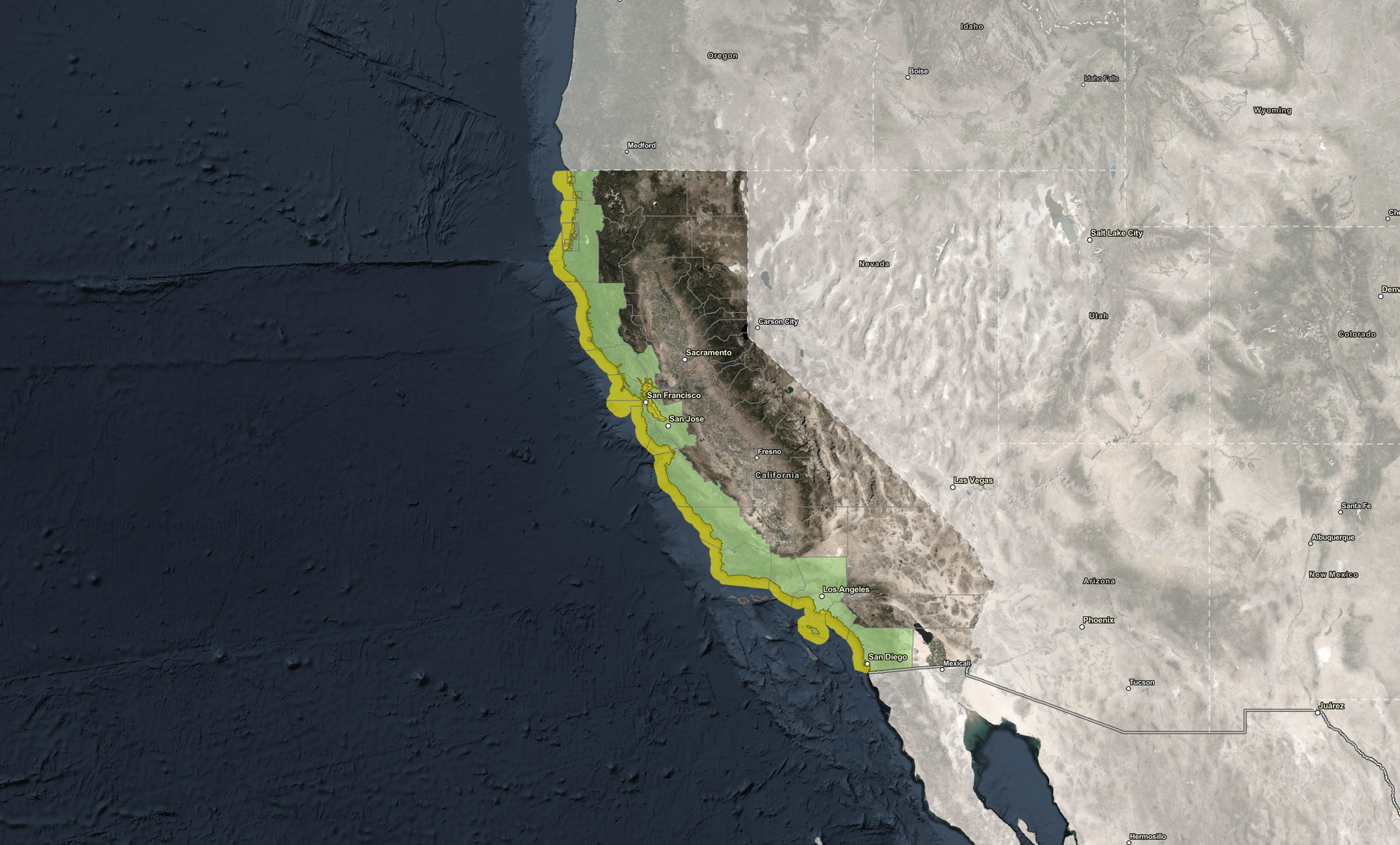
For residents and visitors looking to understand their immediate risk and plan evacuation routes, the California Tsunami Hazard Area Map is a critical tool. Developed by the California Geological Survey, this interactive map allows you to check whether your location is in a tsunami hazard zone—and shows where to go if evacuation becomes necessary.
Below, we explain:
- How to check whether your location falls inside a tsunami hazard zone
- What the map’s colors and boundaries actually mean
- Where to find county-specific evacuation routes and emergency updates
What You'll Find on the Tsunami Hazard Map
The California Tsunami Hazard Area Map displays two main zones:
- Yellow areas represent official tsunami hazard zones. These are based on the maximum expected tsunami inundation, modeled using a range of extreme but plausible tsunami sources. These include scenarios with a 975-year average return period and some localized tsunami threats not included in probabilistic forecasts.
- Green areas lie outside the tsunami hazard zone. These are considered safer ground in the event of a tsunami and are the recommended evacuation destinations.
The boundaries of the yellow hazard zones are not arbitrary—they follow topographic features, city streets, and other landmarks that help emergency planners and residents prepare for worst-case flooding events. While not designed for regulatory or real estate use, the map offers the best scientific understanding available of where tsunami water is likely to reach.
How to Use the Map for the Current Tsunami Advisory
To check if you are in a tsunami hazard zone during the current advisory—or any future one—use the map’s built-in tools:
- Search your address in the “Find address or place” bar and click the magnifying glass. The map will zoom in and highlight your location, showing whether it falls in the yellow hazard zone.
- Use the “My Location” feature to automatically detect your device’s current location. On mobile phones and tablets, this uses GPS to pinpoint your position. On desktop, it relies on your network and browser.
- Zoom manually using the “+” and “–” tools to explore your location and surrounding areas.
If you are in a yellow tsunami hazard zone, the guidance is clear: evacuate by foot immediately after a long or strong earthquake to a nearby green area outside the hazard zone. These maps are specifically designed to help you plan that path ahead of time—whether you're at home, work, or visiting the coast.
Many hazard zones were updated in 2020 or 2022, reflecting improved tsunami modeling and field verification with local emergency officials, making the map one of the most accurate and trusted tools available for California coastal preparedness.
Step-by-Step Instructions
Method 1 – Search Your Address
The easiest way to check whether you're in a tsunami hazard area is to type your address directly into the “Find address or place” bar located at the top-left corner of the map. After entering your address, click the magnifying glass icon. The map will zoom into your location and display whether it falls inside a yellow-shaded tsunami hazard area or in a green evacuation zone.
If your address appears inside the yellow zone, plan your route now to the nearest green area.
Method 2 – Use “My Location”
For those on the move—or unfamiliar with the area—clicking the “My Location” button provides a fast, GPS-based assessment of your current risk. On a mobile device, this feature uses your phone or tablet’s GPS to detect your exact location. On a desktop, it uses your internet connection to approximate your position through the browser.
This method is especially helpful for tourists, delivery drivers, field workers, and anyone visiting a coastal area they don’t know well.
Method 3 – Zoom and Navigate
If you prefer a manual approach or are scanning a larger area (such as multiple homes, workplaces, or schools), use the zoom controls in the top left corner of the map. You can scroll to zoom in or out and click-and-drag to move the map view. This allows you to see the layout of yellow and green zones across neighborhoods, city blocks, and coastal highways, making it easy to trace a walkable evacuation route.
What to Do If You Are in a Tsunami Hazard Area
According to the California Office of Emergency Services (Cal OES), the protocol is simple and urgent:
If you feel a strong or long-lasting earthquake, evacuate by foot immediately to higher ground outside the hazard area. Do not wait for official confirmation of a tsunami.
This applies to homes, schools, workplaces, hotels, and any other place located in a yellow-shaded hazard zone.
Planning ahead is crucial. Use this tool now to identify your nearest green zone and plan your route before an event occurs. Remember that tsunamis often arrive in multiple surges, and the first wave is not always the largest. Hazards can continue for several hours after the initial arrival.
Accuracy and Limitations of the Map
While the Tsunami Hazard Area Map is based on the best available science and modeling, it is important to understand what it does and does not provide.
- This map shows maximum modeled inundation, meaning it reflects the worst-case scenarios from multiple types of potential tsunami events.
- It does not provide real-time wave height data, nor does it predict how large or small a specific tsunami will be.
- Evacuation needs during an actual event may be broader than the mapped yellow zones, based on evolving local conditions or orders from emergency officials.
The map is designed as a planning and preparedness tool, not a guarantee. For real-time alerts and evacuation orders, always follow guidance from official local authorities during an actual tsunami advisory or warning.
Get County-Level Evacuation Info Here
For local emergency plans, real-time alerts, and evacuation guidance tailored to your region, use the links below.
Browse all regional emergency services pages here
1. Humboldt County Office of Emergency Services
2. Redwood Coast Tsunami Work Group tsunami and earthquake information
4. Los Angeles County Office of Emergency Management
5. Monterey County Office of Emergency Services
6. San Mateo County Emergency Preparedness
7. County of Santa Clara Emergency Management
8. Contra Costa County Office of the Sheriff Emergency Services Division
9. San Francisco Department of Emergency Management
11. County of Orange Emergency Services
12. Santa Barbara County Office of Emergency Management (SBOEM)
13. Marin County Office of Emergency Services
15. Ready San Diego
16. Santa Cruz County Office of Response, Recovery & Resilience
17. Solano County Office of Emergency Services
These official emergency services pages correspond to counties included in the California Tsunami Hazard Map.
Additional Resources
To learn more about tsunami safety, evacuation planning, and seismic risk in California, visit:
- State of California Geological Survey Tsunami Information
- California Governor’s Office of Emergency Services, Planning, Preparedness, and Prevention, Seismic Hazards
- California Tsunami Preparedness Guide
Stay Prepared: Know Your Zone Before the Waves Arrive
Whether you live on the coast or are just visiting, don’t wait for a siren or alert to figure out if you’re at risk. Use this map ahead of time to check your location, plan a safe walking route to higher ground, and save emergency contacts from your local agencies.
Tsunami waves can arrive long after the initial quake and often strike in multiple surges. Preparation—not panic—is what saves lives.


