NASA satellites show wildfire smoke from Canada reaching deep into U.S.
New satellite imagery reveals the dramatic spread of smoke from Canadian wildfires into the U.S.


Smoke from Canada’s historic wildfire season is now plainly visible across much of the continental United States, as new satellite imagery and aerosol index maps from NASA show the scale and reach of the plumes affecting North American air quality.
Watch the smoke spread: NASA timelapse
Using aerosol index data from NASA’s VIIRS and OMPS instruments, the timelapse below visualizes how wildfire smoke moved across North America between May 24th and June 11th.

The animation highlights the densest concentrations of smoke—shown in red and orange—traveling southeast from fire zones in Alberta, Saskatchewan, and Manitoba into the central and eastern United States. Elevated aerosol levels are also seen drifting over the Atlantic and as far south as Florida.
Still satellite image captures peak smoke coverage on May 31
To complement the timelapse, the still image below, taken on May 31 by NASA’s EPIC satellite provides a detailed snapshot of how the smoke appeared over North America at a single point in time.
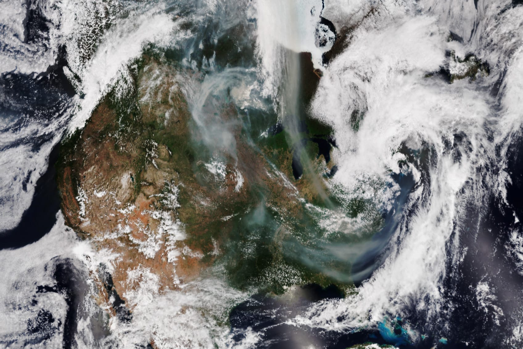
The NASA EPIC image shows a thick band of smoke blanketing the Midwest and Great Lakes region on May 31, with distinct plumes extending into New York, Pennsylvania, and New England—highlighting how far the wildfire smoke had traveled into the eastern U.S. by the end of the month.
A planetary view of Canada’s wildfire smoke
Captured from over 1 million miles away, this global EPIC image shows wildfire smoke streaming eastward from central Canada across the Atlantic Ocean, with faint plumes even visible near Europe.
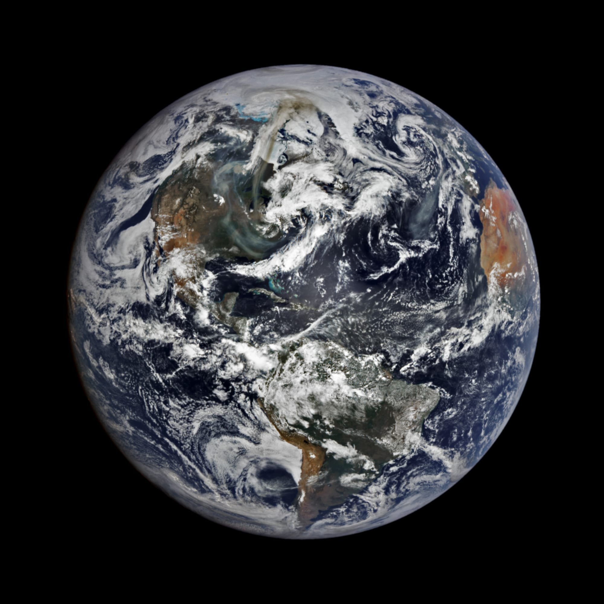
The smoke’s massive scale underscores how far it has traveled beyond the immediate burn zones in Saskatchewan and Manitoba—part of a fire season that’s already impacted air quality in both Canada and the United States.
U.S. air quality impacted by smoke
In the days leading up to June 12, states including Michigan, Minnesota, and Ohio have experienced notable drops in air quality due to elevated particulate matter. On May 30, Michigan issued an air quality advisory for sensitive groups. On June 2, Minnesota followed with an alert as PM2.5 levels neared hazardous thresholds.
Even areas as far south as northern Florida reported atmospheric haze and altered sky colors, including orange sunsets—a visual effect caused by smoke particles suspended high in the atmosphere.
Explore active fires in Canada on NASA’s interactive map
NASA’s Worldview tool allows users to zoom in on individual fire zones using thermal anomaly data from the Suomi NPP satellite.
The red dots on the map above represent active wildfires concentrated across Alberta, Saskatchewan, and Manitoba. Zoom out for a wider view of more active fires across North America.
Fires force evacuations and stretch firefighting resources
The smoke originates from a record-breaking fire season in Canada, which has already seen over 1,700 wildfires burn through 2.2 million hectares of land—an area more than three times the 10-year average.
Data collection has been slow due to reporting issues caused by the heavy smoke. As of the latest official update, issued June 4th, the largest fires include:
- Lower Fishing Lake Fire (Saskatchewan): 407,956 hectares
- Bird River Fire (Manitoba): 198,000 hectares
- La Ronge Region Fires (Saskatchewan): Over 83,000 hectares combined
These and other out-of-control wildfires have prompted evacuations in more than a dozen communities and provincial parks. Both Saskatchewan and Manitoba declared states of emergency in late May, with Manitoba evacuating over 17,000 people so far.
Resource shortages prompt international aid
Canada is currently at National Preparedness Level 5, the highest possible rating, indicating that all domestic firefighting resources are committed. Additional crews and equipment are now being mobilized from international partners, including the United States, under interagency agreements.
Meanwhile, U.S. wildfire risk remains moderate, but several states are monitoring the possibility of imported smoke and its effects on public health, especially in vulnerable communities.
What’s next?
As of June 12, U.S. air quality is still fluctuating day-to-day due to shifting wind patterns. NASA's tools—including the VIIRS aerosol index and the DSCOVR satellite—will continue to offer real-time updates on the smoke’s path, giving the public and officials a high-level view of this ongoing environmental event.


