
Smoke levels reach hazardous highs across Los Angeles County following January wildfires
Los Angeles County faces hazardous smoke levels after January's devastating wildfires.

As Los Angeles County recovers from a series of devastating January wildfires, residents are now facing a dangerous and persistent secondary crisis: severely degraded air quality. Smoke from the fires has left PM2.5 levels—a measure of fine particulate matter—in hazardous ranges across much of the region, posing a serious health risk to millions.
Updated Los Angeles County PM2.5 Data
On Wednesday, January 22nd, 2025, new Los Angeles County air quality data from the California Air Resources Board (CARB) revealed the extent of the pollution:
| Basin | County | Monitoring Site | Days Above National Std. | 1-Hr Maximum | 1-Day Average |
|---|---|---|---|---|---|
| SC | Los Angeles | Compton-700 North Bullis Road (-) | 4 | 183.4 | 51.7 |
| SC | Los Angeles | Glendora-Laurel (-) | 0 | 69.1 | 30.0 |
| SC | Los Angeles | Long Beach-Route 710 Near Road (-) NR | 4 | 196.7 | 45.4 |
| SC | Los Angeles | Long Beach-Signal Hill (-) | 2 | 77.2 | 45.4 |
| SC | Los Angeles | Los Angeles-North Main Street (-) | 2 | 483.7 | 109.3 |
| SC | Los Angeles | North Hollywood (-) | 2 | 136.0 | 50.1 |
| SC | Los Angeles | Reseda (-) | 1 | 150.6 | 47.0 |
| SC | Los Angeles | Santa Clarita (-) | 0 | 28.6 | 17.8 |
The fine particulate matter at the Los Angeles monitoring station on North Main Street measured 109.3 µg/m³, the highest 1-day average and more than three times the EPA’s threshold for healthy air. Similarly, sites in Compton (51.7 µg/m³), North Hollywood (50.1 µg/m³), and Reseda (47.0 µg/m³) all reported averages well above the safety standard of 35 µg/m³.
PM2.5 levels, measured in micrograms per cubic meter (µg/m³), provide a clear indicator of the ongoing air quality crisis. These fine particles, smaller than the width of a human hair, are particularly harmful because they can penetrate deep into the lungs and even enter the bloodstream.
Areas including Los Angeles-North Main Street recorded 1-Hr Maximum PM2.5 levels as high as 483.7 µg/m³, suggesting acute spikes in pollution during the height of the fires. Even in less affected areas like Santa Clarita, daily averages reached 17.8 µg/m³, demonstrating how far the smoke has spread.
Wildfires Behind the Smoke
The dangerous smoke levels are directly tied to the January 7 wildfires that swept across Southern California, burning tens of thousands of acres and leaving destruction in their wake.
The Palisades Fire, which tore through the western part of Los Angeles County, burned 23,448 acres and was only 65% contained as of this morning's report from CalFire. The fire also destroyed an estimated 7,400 structures, further contributing to air pollution from burning buildings and vegetation.
At the same time, the Eaton Fire, which erupted in the northern part of the county, consumed 14,021 acres and was 89% contained. With over 10,400 structures reported damaged or destroyed, the blaze added to the thick, smoke-filled air blanketing the region.
Combined, these fires burned nearly 40,000 acres, while smaller, contained fires contributed additional smoke and particulate matter to the atmosphere.
Health Impacts and Safety Concerns
Health experts warn that prolonged exposure to PM2.5 can cause respiratory issues, cardiovascular strain, and other serious health complications.
As smoke and ash from the #EatonFire and #PalisadesFire continue to affect our #airquality, putting together a #Wildfire Preparedness Plan with your family is critical.
— South Coast AQMD (@SouthCoastAQMD) January 21, 2025
Follow these preparedness tips for before, during and after #wildfire smoke events: https://t.co/Ek1ASIkQdL pic.twitter.com/n7NLf5isMR
With PM2.5 averages exceeding safety limits at nearly every monitoring site in Los Angeles County, the region’s residents—especially vulnerable populations including children, the elderly, and those with pre-existing conditions—are at heightened risk.
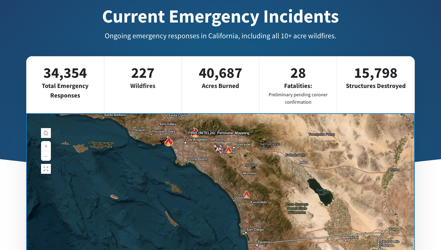
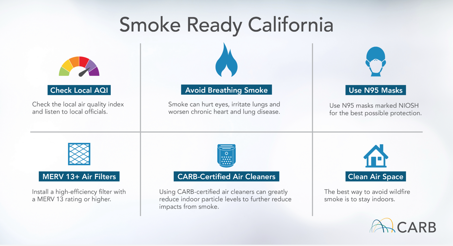
As fires continue to smolder, emergency responses have exceeded 34,000 incidents, and air quality remains a top concern. Public health officials are urging residents to limit outdoor activities, use air purifiers indoors, and wear N95 masks when outside to protect against the lingering effects of the smoke.
Ongoing Efforts and Long-Term Recovery
Efforts to contain the fires have made progress, with crews achieving 89% containment for the Eaton Fire and 65% containment for the Palisades Fire. However, the fires have already burned over 40,000 acres, destroyed 15,798 structures, and displaced tens of thousands of residents. Emergency responses continue, with firefighters working tirelessly to secure the affected areas and prevent flare-ups.
For those returning home, the impact of smoke and ash remains a significant challenge. Cleanup efforts are underway, but the scale of the destruction highlights the long road ahead for rebuilding and recovery.
Protecting Yourself from Smoke Exposure
Residents in Los Angeles County are advised to take precautions as smoke levels remain high:
You can check current Los Angeles air quality levels, fire risks, and weather forecasts here.
Conclusion
The January wildfires have left Los Angeles County grappling with more than just burned land and destroyed homes. The lingering smoke has created an air quality crisis, with PM2.5 levels in the hazardous range across much of the region. As containment efforts continue, residents face a dual challenge: recovering from the fires while protecting themselves from the long-term health risks posed by polluted air.
By staying informed and taking proactive measures, communities can begin to navigate this difficult period of recovery.


