Heavy rain and flash flood watches blanket Southern California as storm moves down the coast
A powerful Pacific storm is moving south down the California coast, bringing several hours of heavy rain, gusty winds, and the threat of flash flooding to Los Angeles, Ventura, and Santa Barbara counties through Tuesday, according to the National Weather Service.


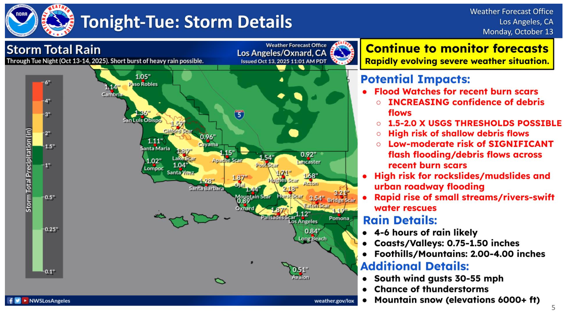
A strong Pacific storm is tracking south down the California coast, bringing widespread rain, gusty winds, and the potential for flash flooding across Southern California through Tuesday.
The National Weather Service Los Angeles/Oxnard Forecast Office reports that four to six hours of steady rain are expected, with coastal and valley areas forecast to receive between 0.75 and 1.5 inches and foothill and mountain regions seeing 2 to 4 inches. The agency warns that Flood Watches are in effect, particularly for areas near recent burn scars, where debris flows and mudslides are possible.
Officials highlight an “increasing confidence of debris flows” and a high risk of shallow debris slides in steep terrain, along with a low-to-moderate risk of significant flash flooding across urban areas and small streams.
Winds are expected to gust between 35 and 55 mph from the south, and thunderstorms are possible throughout the day. The highest elevations, above 6,000 feet, could see accumulating snow under an active Winter Storm Warning.
Central and Northern California Begin to Dry Out
Farther north, the NWS Bay Area Forecast Office reported that all flood-related warnings and advisories expired late Monday night, though scattered showers continue. Radar imagery from 11:23 p.m. Monday showed rain bands shifting southeast through Monterey Bay and into the Central Coast, consistent with the storm’s southward movement.
📡Radar Update[11:30 PM] - All flooding products have been allowed to expire. However, rain chances have not ended. The chance for lingering showers will continue through the night. Some showers will produce locally heavy rain, heads up on roads w/ ponding possible. #cawx pic.twitter.com/aErqf5nsg0
— NWS Bay Area 🌉 (@NWSBayArea) October 14, 2025
“Rain chances have not ended,” the Bay Area office said in a 11:30 p.m. update on social media. “Some showers will produce locally heavy rain — heads up on roads with ponding possible.”
Flood Watches Remain in Effect for Southern California
The latest hazard map from the NWS Los Angeles office shows Flood Watches extending across Los Angeles, Ventura, and Santa Barbara counties, with Severe Thunderstorm Warnings earlier in effect for parts of San Luis Obispo County.
Residents are urged to avoid travel through canyons, low-lying roads, and recently burned areas, as rapidly changing conditions could lead to flash flooding or debris flows. The NWS also cautions that small creeks and rivers may rise quickly during the heaviest rainfall periods.
What’s Next
Conditions are expected to gradually improve by late Tuesday as the system moves further south and east, but forecasters urge continued caution until rain and runoff subside.
“Continue to monitor forecasts,” the Los Angeles office advises. “This remains a rapidly evolving severe weather situation.”


