
Climate change increased likelihood of wildfires in highly exposed LA area, new study finds
Climate change increased the likelihood of the January 2025 wildfires in Los Angeles, according to a new study from World Weather Attribution.

A new study released by World Weather Attribution finds that human-induced climate change significantly increased the likelihood of extreme fire weather conditions that fueled the LA wildfires. Scientists from the United States, the Netherlands, Denmark, Belgium, France, Sweden, and the United Kingdom collaborated to assess the role of global warming in the fires' intensity and spread.
Scientists at @WWAttribution have found that human-induced warming made extreme fire weather 35% more likely & intensified wildfire conditions in the LA area.https://t.co/WGzATAZZLI pic.twitter.com/b4msBB0nfN
— California Today (@Ca_Today_Com) January 29, 2025
Key Takeaways:
- Climate change increased the likelihood of extreme fire weather in LA by 35% and intensified it by 6%.
- The dry season has extended by 23 days, overlapping more frequently with peak Santa Ana winds.
- Air quality across LA County reached hazardous levels, with PM2.5 pollution exceeding EPA limits in multiple areas.
- Lower-income and historically marginalized communities were disproportionately impacted.
- Los Angeles’ firefighting infrastructure struggled with water supply and pressure issues.
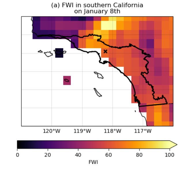
The study findings show that in today's climate—1.3°C warmer than preindustrial levels—fire weather conditions as severe as those seen in January 2025 are now 35% more likely than they were in a cooler climate. The Fire Weather Index (FWI), which tracks temperature, humidity, wind speed, and precipitation, increased by 6% in intensity due to global warming.
The length of the dry season—a critical factor in fire risk—has also extended by 23 days compared to past decades. Historically, seasonal rainfall from October to December would end the fire season by moistening vegetation and making fires harder to spread. However, 2024 was nearly rainless from October to December, leaving parched grasslands and brush primed to ignite.
Another major factor was the unusual strength of the Santa Ana winds, which typically occur from October to March. The World Weather Attribution study found the atmospheric circulation pattern responsible for these winds has become more frequent, further increasing fire risk.
The study projects that if global warming reaches 2.6°C by 2100, which is the minimum expected under current policies, extreme wildfire conditions like these will become an additional 35% more likely and even more intense.
Air Quality Crisis: A Deadly Aftermath
As we reported last week, the Los Angeles area is now facing a severe air quality crisis beyond the destruction of homes and landscapes. The fires produced massive amounts of fine particulate matter (PM2.5), a hazardous pollutant that can penetrate deep into the lungs and bloodstream.
Data from the California Air Resources Board (CARB), collected on January 22, 2025, reveals dangerously high PM2.5 levels across Los Angeles County, exceeding EPA safety thresholds at nearly every monitoring site.
| Basin | County | Monitoring Site | Days Above National Std. | 1-Hr Maximum | 1-Day Average |
|---|---|---|---|---|---|
| SC | Los Angeles | Compton-700 North Bullis Road (-) | 4 | 183.4 | 51.7 |
| SC | Los Angeles | Glendora-Laurel (-) | 0 | 69.1 | 30.0 |
| SC | Los Angeles | Long Beach-Route 710 Near Road (-) NR | 4 | 196.7 | 45.4 |
| SC | Los Angeles | Long Beach-Signal Hill (-) | 2 | 77.2 | 45.4 |
| SC | Los Angeles | Los Angeles-North Main Street (-) | 2 | 483.7 | 109.3 |
| SC | Los Angeles | North Hollywood (-) | 2 | 136.0 | 50.1 |
| SC | Los Angeles | Reseda (-) | 1 | 150.6 | 47.0 |
| SC | Los Angeles | Santa Clarita (-) | 0 | 28.6 | 17.8 |
Los Angeles-North Main Street recorded an alarming daily PM2.5 average of 109.3 µg/m³—more than three times the EPA threshold for healthy air. Other locations, including Compton, North Hollywood, and Reseda, all exceeded 45 µg/m³, putting millions of residents at risk.
The Road Ahead: Climate Adaptation and Fire Preparedness
With the increasing likelihood of extreme wildfires due to climate change, the study highlights an urgent need for Los Angeles and other wildfire-prone regions to invest in stronger fire mitigation policies, more resilient infrastructure, improved emergency response systems, and climate adaptation strategies.


