Gifford Fire expands past 91,000 acres: Updated evacuation zones, road closures, and shelter info for Thursday morning
The Gifford Fire has burned more than 91,000 acres in San Luis Obispo and Santa Barbara counties as of Wednesday night, with new evacuation orders, road closures along Highway 166, and expanded shelter resources now in effect.


The Gifford Fire has grown explosively to 91,250 acres with just 9% containment as of late Wednesday night, August 6, 2025. CAL FIRE reports that three civilians and four firefighters have been injured as the fire continues burning on both sides of Highway 166 northeast of Santa Maria.
With active fire behavior reported on the southern flank, officials are expanding evacuation orders and warnings across both Santa Barbara and San Luis Obispo counties. Highway 166 remains closed in both directions between Highway 101 and New Cuyama.
#GiffordFire Evening Update August 6,2025
— Los Padres NF (@LosPadresNF) August 7, 2025
Active fire persisted today on the north side of the fire prompting new evacuation orders and warnings in San Luis Obispo County.
🔗To see full article, please visit https://t.co/zNPi6BHfyS pic.twitter.com/HhiQei7CaN
New evacuation orders and warnings issued
Unified Command—which includes Los Padres National Forest and Santa Barbara County Fire—has updated evacuation zones due to increased fire spread and wind shifts. The following are the latest:
🔴 Evacuation Orders
San Luis Obispo County
- LPF-011, LPF-013 to LPF-019
- SLC-225, SLC-239, SLC-240, SLC-263, SLC-264, SLC-297, SLC-298, SLC-335 to SLC-337
Santa Barbara County
- LPF-165
- SBC-159-A, SBC-161-A, SBC-163, SBC-167, SBC-169-A, SBC-169-B
🟡 Evacuation Warnings
San Luis Obispo County
- LPF-002, LPF-003, LPF-009 to LPF-010, LPF-012
- SLC-195, SLC-196, SLC-197, SLC-224, SLC-226, SLC-261, SLC-262, SLC-311, SLC-312, SLC-334
Santa Barbara County
- SBC-159-B, SBC-161-B, SBC-172, SBC-179, SBC-229-A
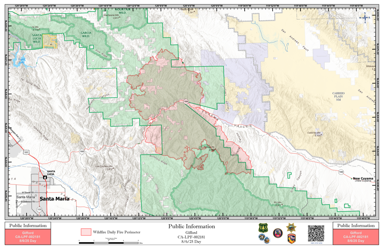
Road closures and restricted access
Highway 166 remains fully closed between Highway 101 and New Cuyama. Non-emergency vehicles are restricted from entering east of Tempusquet Road and west of Perkins Road. Authorities have asked the public to avoid the area and use alternate routes.
For a real-time view of satellite activity over the fire zone, use the interactive map below. This NOAA tool shows live fire perimeters, thermal hotspots, smoke coverage, and surface observations across the Gifford Fire area.
Where to find help
Temporary evacuation points and information centers:
- Benjamin Foxen Elementary School
- 4949 Foxen Canyon Rd, Santa Maria, CA
- Open August 3–4, 8:00 AM – 7:00 PM
- Cuyama Valley Family Resource Center
- 4689 Highway 166, New Cuyama, CA
- Open August 3–4, 8:00 AM – 4:00 PM
- Sheltering assistance: Call the Red Cross at (805) 678-3073.
Animal evacuation resources
For large animal evacuations, residents are encouraged to call the County Animal Services Disaster Hotline at (805) 681-4332. The Elks Rodeo Grounds (4040 Highway 101, Santa Maria) remains open for large animals—enter through Morningside Drive Gate 2.
Small/domestic animal shelters open until 6:00 PM at:
- 548 W Foster Rd, Santa Maria
- 1501 W Central Ave, Lompoc
- 5473 Overpass Rd, Goleta
- 111 Commerce Dr, Buellton (open until 5:00 PM)
See wildfire alerts in near-real time:
Use NOAA’s Next‑Generation Fire System (NGFS) interactive map below to zoom in on current hot spots and updated perimeters across California. The NGFS updates every 60 seconds—providing minute-scale detection, all-weather acuity backed by AI, and continuous live tracking of fire progression.
Resources fighting the fire
CAL FIRE and Los Padres National Forest have nearly 3,000 personnel on the fire line, including:
- 202 engines
- 18 water tenders
- 19 helicopters
- 101 dozers
- 76 hand crews
- 498 support personnel
Firefighting air tankers are being deployed statewide as conditions allow.
Gifford Fire update – 11:00 PM PT, Monday, August 4
— California Today (@Ca_Today_Com) August 5, 2025
The Gifford Fire has burned 72,460 acres northeast of Santa Maria and is just 3% contained as of 6:02 PM.
Evacuation orders and road closures are still in effect across parts of Santa Barbara and San Luis Obispo counties.… pic.twitter.com/NwMGDKyEKN


