Gifford Fire explodes past 72,000 acres: Evacuation orders, fire maps, and road closures in SLO and Santa Barbara
The Gifford Fire is now California’s largest active wildfire, forcing mandatory evacuations and closing Highway 166 in the Central Coast. Check your zone status, animal shelter info, and real-time maps.


Update – August 7, 2025: The Gifford Fire has now burned more than 91,000 acres, with expanded evacuation zones and updated road closures in San Luis Obispo and Santa Barbara counties. For the latest evacuation map, injury reports, and live wildfire tracking tools. Read our full August 7 update:
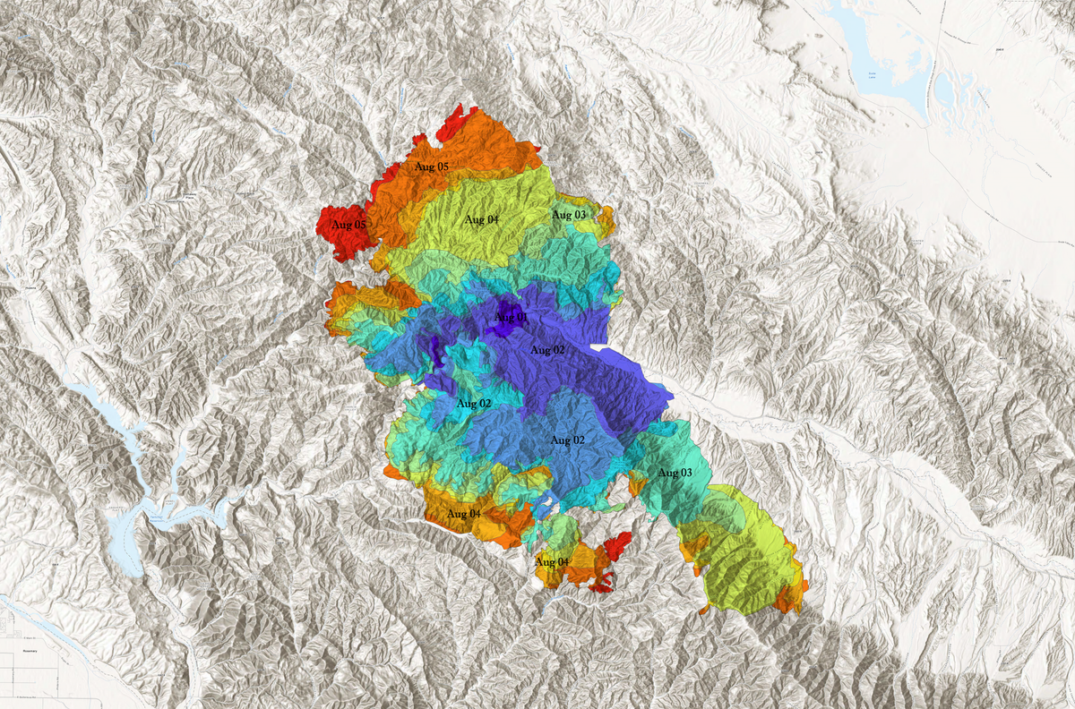
The Gifford Fire has scorched 72,460 acres in San Luis Obispo and Santa Barbara counties since igniting on August 1, prompting mandatory evacuation orders, road closures, and an expanding network of emergency shelters across California’s Central Coast.
As of Monday night, the fire was just 3% contained and remains one of the top 10 active wildfires statewide—by far the largest currently burning in California. Flames continue to push aggressively along both sides of Highway 166, northeast of Santa Maria, with especially active spread reported on the south side of the highway.
Here's a projection for the smoke from the #GiffordFire 🔥in San Luis Obispo/Santa Barbara Counties through tomorrow night. Smoke will generally move towards the south and east. pic.twitter.com/fzb05X833b
— NWS Los Angeles (@NWSLosAngeles) August 4, 2025
The blaze is now under Unified Command between Los Padres National Forest and Santa Barbara County Fire, with incident management led by California Interagency Incident Management Team 5 (CAIIMT 5). The fire’s cause remains under investigation.
Mandatory evacuation orders in effect
Evacuation orders—defined as an immediate threat to life—have been issued across multiple fire zones in San Luis Obispo and Santa Barbara counties. Residents in these areas are required to leave immediately.
San Luis Obispo County evacuation zones:
- LPF-014, LPF-015, LPF-016, LPF-017, LPF-018, LPF-019
- SLC-335, SLC-336, SLC-337
Santa Barbara County evacuation zones:
- LPF-165
- SBC-159-A, SBC-161-A, SBC-163, SBC-167, SBC-169-A, SBC-169-B
Evacuation warnings: Be ready to leave
Evacuation warnings are in effect for additional zones where fire activity could intensify. Those who need extra time to evacuate—especially individuals with pets, livestock, or mobility limitations—are strongly urged to relocate now.
San Luis Obispo County evacuation warnings:
- SLC-225, SLC-239, SLC-240, SLC-262, SLC-264
- SLC-297, SLC-298, SLC-311, SLC-312, SLC-334
- LPF-011, LPF-013
Santa Barbara County evacuation warnings:
- SBC-159-B, SBC-161-B, SBC-172
For a real-time view of satellite activity over the fire zone, use the interactive map below. This NOAA tool shows live fire perimeters, thermal hotspots, smoke coverage, and surface observations across the Gifford Fire area.
Road closures
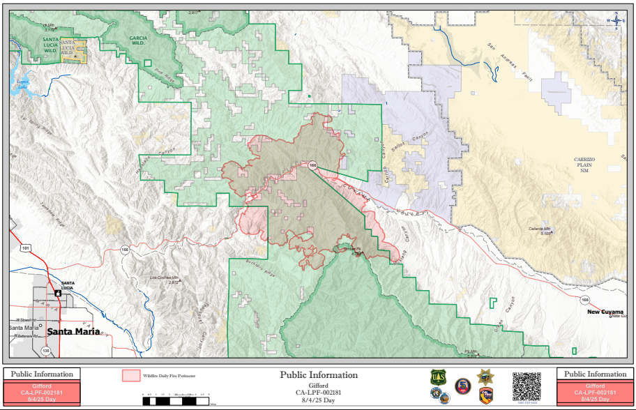
Highway 166 remains fully closed between Highway 101 and New Cuyama, cutting off one of the Central Coast’s key inland routes. Drivers should avoid the area entirely and check local advisories before traveling.
Emergency shelters and evacuation points
Residents in need of temporary shelter or evacuation assistance can call the American Red Cross at 805-678-3073 or visit one of the designated evacuation centers below:
Temporary Evacuation Points
- Benjamin Foxen Elementary School
- 4949 Foxen Canyon Rd, Santa Maria, CA
- Hours: Monday, August 3 and Tuesday, August 4 (8 AM – 7 PM)
- Cuyama Valley Family Resource Center
- 4689 Highway 166, New Cuyama, CA
- Hours: Monday, August 3 and Tuesday, August 4 (8 AM – 4 PM)
Animal evacuation resources
Evacuation support is also available for both large and small animals in the affected areas. Residents are encouraged to act early and avoid delaying animal relocations.
For large animals:
Call the County Animal Services Disaster Hotline at 805-681-4332 for immediate assistance.
- Elks Rodeo Grounds
4040 Highway 101, Santa Maria
(Enter through Morningside Drive Gate 2)
For small/domestic animals (open until noted times):
- 548 W Foster Rd, Santa Maria – open until 6 PM
- 1501 W Central Ave, Lompoc – open until 6 PM
- 5473 Overpass Rd, Goleta – open until 6 PM
- 111 Commerce Dr, Buellton – open until 5 PM
Fire behavior and containment outlook
As of August 5, the Gifford Fire remains highly active, with significant growth expected if weather and terrain continue to favor rapid spread. Officials say fire activity is most intense on the south side of Highway 166, and containment remains low at just 3%.
The blaze is being managed as part of a multi-agency unified command, and CAIIMT 5 assumed control on August 3. While the full scope of damage is still being assessed, containment efforts are ongoing in tandem with life-safety operations.
Gifford Fire is California’s largest active wildfire
According to Cal Fire’s August 5 update, the Gifford Fire is now the largest wildfire currently burning in California, surpassing nine other active incidents in scale.
Top 10 Active California Wildfires (August 4th, 2025, 10:19 PM):
| Fire | Counties | Acres | Containment |
|---|---|---|---|
| Gifford Fire | San Luis Obispo, Santa Barbara | 72,460 | 3% |
| Orleans Complex | Del Norte, Siskiyou | 21,720 | 81% |
| Green Fire | Shasta | 19,022 | 97% |
| Rosa Fire | Riverside | 1,200 | 0% |
| Big Cliff Fire | Siskiyou | 542 | 0% |
| Lake Fire | Lake | 401 | 50% |
| Gold Fire | San Bernardino | 348 | 0% |
| Medicine Fire | Mendocino | 263 | 85% |
| 1-4 Fire | Lassen | 260 | 25% |
| Claypit Fire | Sacramento | 131 | 55% |
Real-time fire maps and live updates
Residents can monitor official updates and changing perimeter conditions via several online tools:
- Gifford Fire InciWeb page
- ALERTCalifornia Live Cameras – Including feeds from La Panza 2
- ReadySBC.org – Santa Barbara’s official source for local evacuation notices
- Perimeter and wind maps – Include fire boundaries, wind overlay, air assets, and 5-year history (powered by Esri, Genasys, and Perimeter)
Safety guidance
Officials continue to emphasize:
- Do not delay if under evacuation order – leave immediately
- Avoid using Highway 166 for any reason
- Do not approach fire zones to photograph or film
- Keep pets and livestock ready for transport, even under warning
- Rely only on verified sources like InciWeb, ALERTCalifornia, and ReadySBC
As of now, there is no timeline for full containment, and conditions remain dangerous across the region. Stay alert, follow official instructions, and evacuate early if in doubt.


