Santa Ana Winds and Red Flag Warning update for Southern California (1/20/25)
Extreme Santa Ana winds bring 'particularly dangerous' fire weather to Southern California. Red flag warnings in effect.


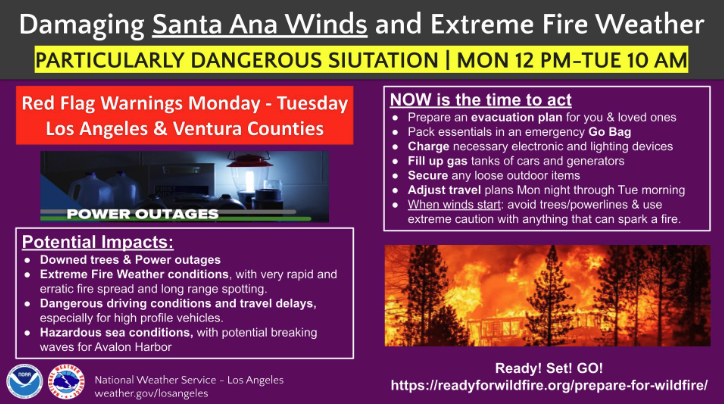
As of 6:00 PM PT on Monday, January 20th, 2025, Southern California is bracing for another unprecedented wind event as the National Weather Service (NWS) has issued a "particularly dangerous situation" red flag warning. This heightened alert—the most extreme version of a red flag warning—forecasts critical fire weather conditions that could lead to rapid fire spread and large fire growth, starting Monday at noon and lasting through 10 a.m. Tuesday.
⚠️POWERFUL & DAMAGING SANTA ANA WINDSTORM INCOMING!!⚠️
— NWS Los Angeles (@NWSLosAngeles) January 19, 2025
Take action now to prepare your home and loved ones for another round of EXTREME WIND and FIRE WEATHER, staring tomorrow afternoon! Worst winds Mon afternoon - Tue morning. #CAwx #SantaAnaWinds pic.twitter.com/CuhRHgOTjF
Areas of Concern
According to the latest National Weather Service data, large swaths of Southern California are under a Red Flag Warning, including Los Angeles, Ventura, Riverside, San Diego, and Orange counties. Areas of particular concern include Malibu, Altadena, Burbank, Santa Clarita, Oxnard, Thousand Oaks, and San Diego’s inland regions.
Forecasts predict gusts of 50 to 70 mph for coastal and valley areas, while mountainous regions and foothills could experience gusts from 60 to 80 mph, with isolated peaks reaching 100 mph. Such conditions, combined with low humidity levels as low as 5%, create an environment primed for wildfires to ignite and spread uncontrollably.
The map also highlights burn areas at higher risk, such as Malibu and Altadena. While some regions, like Ojai and Pasadena, fall outside the warning’s most critical boundaries, residents across the affected areas are urged to take immediate precautions.
Preparation and Safety Guidelines
Authorities are emphasizing the importance of preparation to mitigate potential risks:
- Evacuation Plans: Residents should create or review their evacuation plans, ensuring they account for pets and essential items.
- Emergency Supplies: Prepare emergency go-bags, fill car and generator fuel tanks, and charge electronics and flashlights.
- Securing Property: Move vehicles away from fragile trees, clear gutters and roofs of flammable materials, and secure or remove outdoor furniture, umbrellas, and garbage bins.
- Air Quality Precautions: A windblown dust and ash advisory warns of reduced air quality, particularly near recent burn scars. Use air purifiers indoors and wear masks if outdoors.
Meteorologist Rose Schoenfeld from the NWS emphasized the need for readiness: “We’d encourage people to prepare that evacuation plan for you, your loved one, pets—pack essentials, get that emergency go-bag ready just in case.”
Firefighters Battle Palisades and Eaton Fires
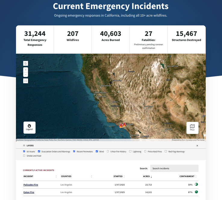
As the new weather event approaches, firefighters are racing to contain the Palisades and Eaton fires. According to Cal Fire’s latest updates, the Palisades Fire, which has scorched 23,713 acres, is currently 59% contained, while the Eaton Fire, which has burned 14,0221 acres, is 87% contained. Together, these fires have claimed 27 lives, with 27 individuals still reported missing as of Sunday.
More than 8,000 fire personnel—including crews from across the United States, Canada, and Mexico—are actively engaged in containment efforts. Officials remain concerned about the potential for new fire ignitions under these extreme conditions.
Ongoing Threat and Forecast
Fire weather concerns will persist throughout the week, with the possibility of additional Santa Ana wind events by Thursday. While there is some chance of rain between January 25 and 27, the forecasted precipitation is unlikely to significantly reduce fire risks.
Residents are advised to stay informed through official updates and to act promptly if evacuation orders are issued. The combination of high winds, dry vegetation, and critical weather conditions makes this an especially dangerous period for Southern California.
Stay tuned for further updates as conditions evolve.


