Heavy rain, debris flow risk, and dangerous surf expected across California through the weekend
A strong Pacific storm is bringing heavy rain, debris flow risks, and dangerous surf to California from Thursday evening through the weekend, with the National Weather Service warning of flooding, hazardous travel, and sneaker waves along much of the coast.


California is heading into a high-impact stretch of weather beginning Thursday evening, with the National Weather Service warning of widespread rain, a growing risk of debris flows in Southern California, and hazardous beach conditions along much of the Pacific Coast, including San Francisco, through Friday.
Showers are quickly developing & moving into Ventura Co now. We've been observing rain rates of 0.10 to 0.25 in/hr, & rain will continue streaming into Santa Barbara, SLO and Ventura Co through the night, increasing in coverage & intensity (becoming moderate to heavy rain). pic.twitter.com/GnA8558nAr
— NWS Los Angeles (@NWSLosAngeles) November 14, 2025
Forecasters say the combination of an arriving storm system, saturated soils in higher terrain, and unusually large surf will bring multiple hazards to residents from Los Angeles to the Bay Area.
Southern California: Increasing Rainfall, Flooding and Debris Flow Risk
According to the National Weather Service office in Los Angeles, rain will steadily increase from Thursday night into Friday, with the highest impacts expected on Saturday. A timing map issued Thursday highlights the greatest concern for Los Angeles, Ventura, Santa Barbara, and San Luis Obispo counties late Friday night through Saturday evening.
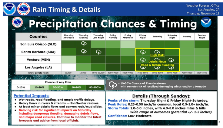
The agency notes a high risk of debris flows, road and urban flooding, and significant travel delays as the storm strengthens. Peak rainfall rates are forecast between 0.25 and 0.50 inches per hour in most areas, with isolated pockets potentially exceeding one inch per hour. Total rainfall through Sunday is expected to reach 2.0 to 5.0 inches for many lower-elevation communities, with 4.0 to 8.0 inches possible in mountains and foothills.
Forecasters continue to emphasize that the range of potential outcomes remains wide, and rainfall amounts may vary by one to two inches depending on the final storm track. Snow levels will stay well above major passes, mainly between 7,000 and 9,000 feet.
Many areas in California are experiencing rain and we want to take the opportunity to remind you to stay aware of your surroundings! During storms conditions can change rapidly so keep an eye out for rushing water, downed powerlines, or any other hazards that could be caused by… pic.twitter.com/LxSCXpYqnI
— California Department of Water Resources (@CA_DWR) November 13, 2025
Bay Area and Central Coast: Hazardous Beach Conditions Through Friday
A separate alert from the National Weather Service office in the San Francisco Bay Area warns of dangerous surf along the Pacific Coast from Thursday afternoon through Friday night. A Beach Hazards Statement is in effect from 3 PM Thursday to 9 PM Friday for the entire coastline.
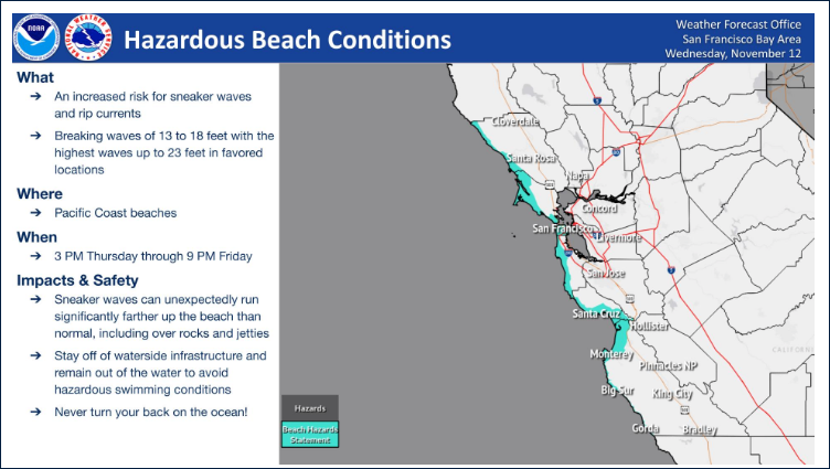
Waves of 13 to 18 feet are expected, with the largest sets potentially reaching 23 feet in favored locations. Rip currents and sneaker waves pose a significant threat to anyone near the shoreline, including on jetties, tidepools, and coastal rocks. The agency stresses that sneaker waves can surge far higher up the beach than normal, catching people unaware.
Residents and visitors are urged to stay off waterside infrastructure and avoid entering the water until conditions improve. Officials also remind beachgoers never to turn their backs on the ocean.
Trillions of gallons of water are forecast to fall across California as a parade of storms slams the state.
— Colin McCarthy (@US_Stormwatch) November 13, 2025
Current projections put this on pace to become one of the top 20 wettest Novembers in California’s recorded history. The state hasn’t had a top-20 wet November since 1998. pic.twitter.com/Vx5wA8NgVo
What’s Next
Both weather offices expect conditions to remain unsettled through Sunday, with additional rainfall chances in Southern California and gradually improving surf farther north by the weekend.
Emergency managers are advising residents in burn scar regions, canyon areas, and flood-prone neighborhoods to stay alert to changing conditions, as rapid-onset debris flows are possible even during moderate rainfall. Travelers should be prepared for delays and localized road closures on Saturday, the period expected to see the most significant impacts across Los Angeles County and surrounding regions.
California Today will continue monitoring updates from the National Weather Service as forecasts evolve.


