Comparing sea level trends: Santa Monica vs. Monterey
Explore how sea levels are rising in Santa Monica and Monterey, with Santa Monica seeing a 6 cm increase since 1993 and both cities projecting a 13 cm rise by 2050.


As coastal cities grapple with the impacts of climate change, understanding regional sea level trends is critical for planning and adaptation. As 2024 comes to a close, the latest data from the US government's Sea Level Explorer offers insight into historical and projected sea level changes in two key California locations: Santa Monica and Monterey. While both cities are experiencing rising sea levels, NASA's satellite imagery reveals subtle differences in past trends while future projections highlight the complexity of localized climate impacts.
Historical Trends: Santa Monica vs. Monterey
From 1993 to present, Santa Monica recorded a 6-centimeter rise in sea level, while Monterey experienced a slightly lower increase of 5 centimeters. 2024's end-of-year data for both cities reflects the influence of human-caused climate change, with fluctuations from natural phenomena such as tides, seasonal changes, and El Niño events.
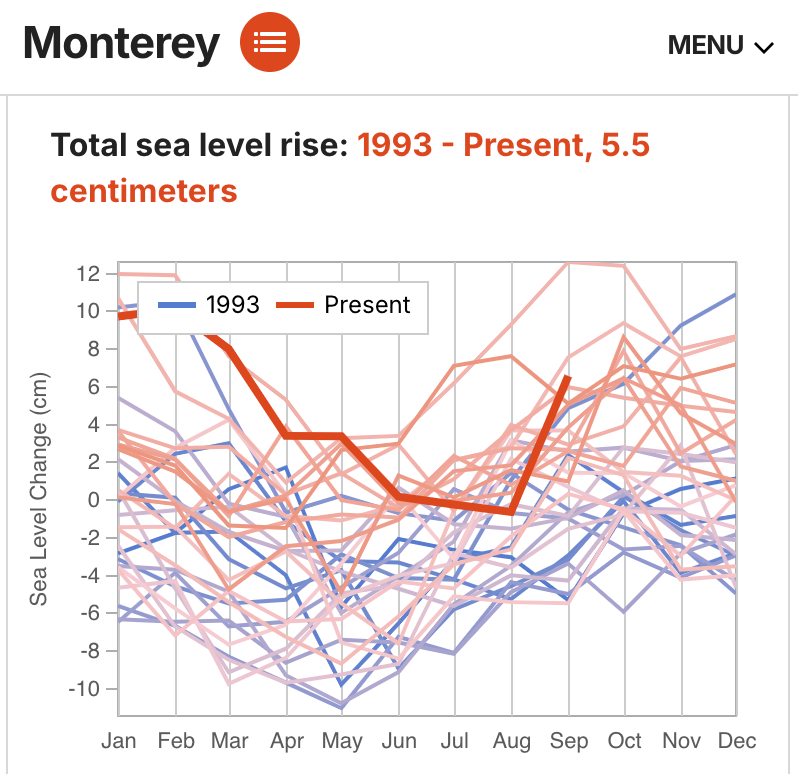
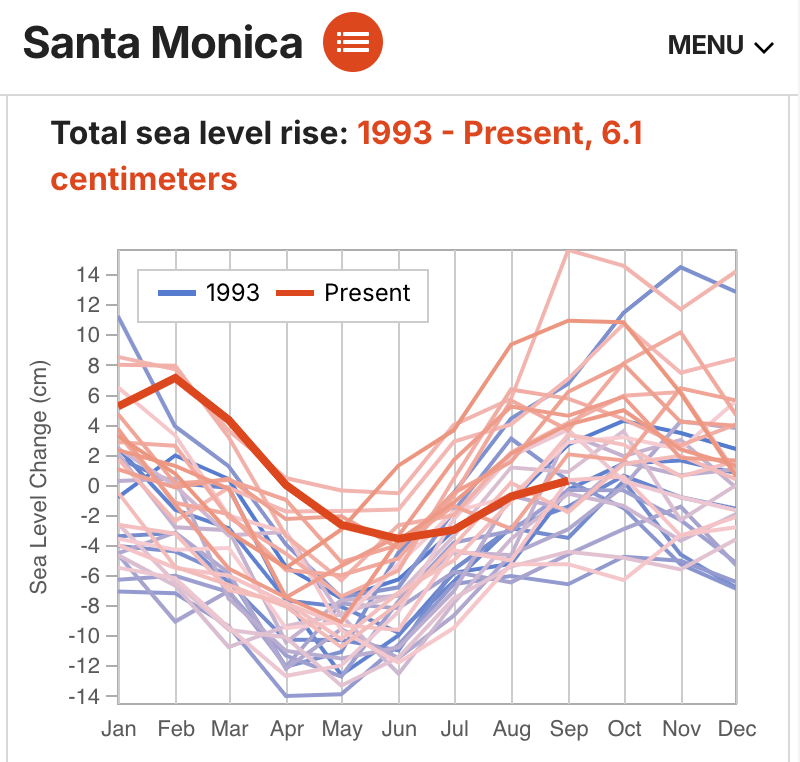
Historical sea level rise: 6 cm in Santa Monica and 5 cm in Monterey since 1993, driven by climate change.
In both locations, the trend is unmistakable. As the Sea Level Explorer notes for Monterey, "In places where sea level is rising, there is an upward shift as the years go by. This change in sea level over the years is caused mainly by human-caused climate change and other local factors." Similarly, for Santa Monica, the report explains, “Sea level goes up and down throughout the year from things like tides and changes in seasons. Some years may also be higher than others due to natural fluctuations from things like El Niño.”
Future Projections: Similar Paths, Identical Risks
Looking ahead, both Santa Monica and Monterey face nearly identical projections for sea level rise under the SSP2-4.5 scenario, a middle-range emissions pathway. Both cities are expected to see a 13-centimeter rise in sea level between 2020 and 2050, with a likely range of 11 to 17 centimeters. These projections align with broader global patterns and highlight the shared vulnerabilities of California's coastal cities.
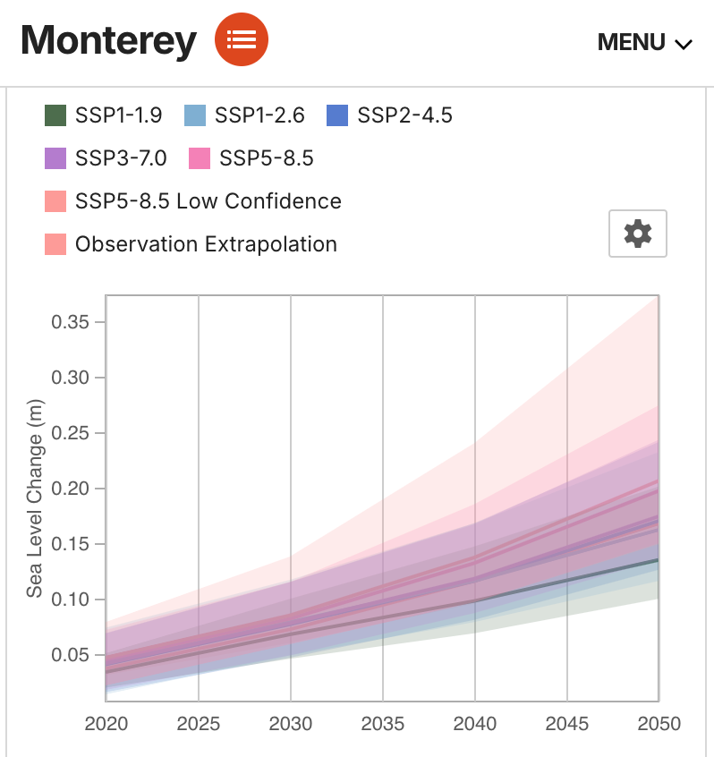
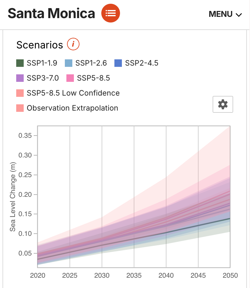
Both Monterey and Santa Monica's sea levels are projected to rise 13 cm by 2050 under mid-range emissions scenarios, with a range of 11 to 17 cm.
The extrapolated data for both cities indicates a 3% chance of exceeding 1 meter of global sea level rise by 2100. As the Monterey report explains, "The bolded line is the currently chosen scenario, which can be changed at the top of the page. The likely ranges for each scenario can also be displayed." This modeling underscores the importance of emissions reductions in determining long-term outcomes.
Seasonal Patterns and Natural Variability
Seasonal and annual cycles also play a role in local sea level observations. In both cities, the data shows that sea levels fluctuate naturally throughout the year due to tides, weather patterns, and seasonal factors. As highlighted in the Santa Monica report, "Sea level goes up and down throughout the year from things like tides and changes in seasons." Monterey’s data mirrors this explanation, noting that "Some years may also be higher than others due to natural fluctuations from things like El Niño."
Despite these short-term variations, the long-term trend of rising sea levels is clear for both locations. The bold red line on both cities’ charts indicates that “the red line will likely continue to rise higher in the future.”
A Shared Call to Action
Though Santa Monica and Monterey exhibit slightly different historical trends, the projected 13-centimeter rise in sea level over the next three decades highlights the urgency for both cities to prepare for a changing coastline. The Sea Level Explorer’s insights reveal not only the shared challenges California’s coastal cities face but also the critical role emissions pathways will play in shaping future outcomes.
As climate change accelerates, understanding these regional variations in sea level rise will be essential for developing resilient infrastructure and protecting coastal communities. Both Santa Monica and Monterey stand at the forefront of these challenges, with data-driven tools providing the guidance needed to navigate an uncertain future.


