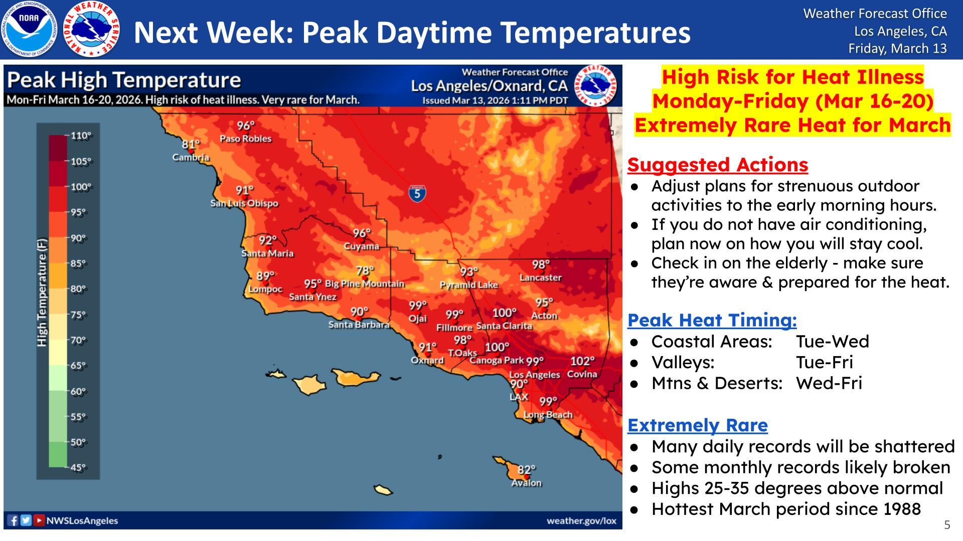
"High Risk for Heat Illness Monday-Friday (Mar 16-20) Extremely Rare Heat for March": NWS updates SoCal heat warning
Southern California faces a historic March heatwave from March 16–20, 2026. With triple-digit records expected, learn how to stay cool and save energy during this rare event.


Southern California is entering a period of historic "weather whiplash" as a massive high-pressure ridge transforms mid-March into a mid-summer furnace. After a Friday that saw decades-old temperature records fall across the Southland, the National Weather Service (NWS) is warning that the most dangerous part of this "extremely rare" event is still to come.
Friday’s Records Fall as "Pre-Game" Heat Hits
The heat arrived with startling intensity on Friday, March 13. According to the NWS Los Angeles, preliminary data shows several high-temperature records were toppled:
Today's record highs include Downtown LA at 92 degrees (previous 90 degrees in 2015), LAX at 88 degrees (previous 86 degrees in 1994), and UCLA at 89 degrees (previous 87 degrees in 2015). #LAWeather #LAheat #cawx
— NWS Los Angeles (@NWSLosAngeles) March 14, 2026
- Downtown Los Angeles hit 92°F, shattering the previous 2015 record of 90°F.
- UCLA reached 89°F, eclipsing the 87°F mark also set in 2015.
- LAX recorded 88°F, surpassing a 1994 record of 86°F.
The Forecast: A Historic Week Ahead
While Friday was intense, it was merely the "pre-game" for a high-risk heat event set to grip the region from Monday, March 16 through Friday, March 20. Forecasters are projecting highs 25-35 degrees above normal, making this the hottest March period since 1988.
Here is a table of record high temperatures for next week. The hottest temps are expected Tue-Thu when monthly records for March could fall. #LAHeat #SoCal #CAwx pic.twitter.com/1OUQGkX9Nc
— NWS Los Angeles (@NWSLosAngeles) March 12, 2026
The NWS San Diego has issued an Extreme Heat Watch for all locations west of the mountain ranges. According to high-resolution probability maps, the intensity will be widespread:
- The Valleys & Inland Empire: There is a 100% probability that San Bernardino will exceed 99°F, with Riverside and Redlands close behind at 92–98%.
- Triple-Digit Threats: Areas like Covina are projected to hit 102°F, while the Coachella Valley faces a 50–65% probability of soaring past 109°F in cities like Palm Springs and Indio.
- The Coast: Relief will be minimal; coastal areas will see their peak heat Tuesday through Wednesday, with Long Beach and Downtown LA projected to hover near 100°F.
Chances of reaching 110 degrees next week: pic.twitter.com/QO5o1oQGM8
— NWS San Diego (@NWSSanDiego) March 13, 2026
Why "March Heat" is Different
The California Department of Public Health notes that early-season heatwaves are particularly dangerous because the human body has not yet had time to "acclimatize" to high temperatures.
Unlike summer heatwaves, residents may not have their air conditioning units serviced or may be caught off guard while engaging in outdoor activities. State officials atHeat Ready CAemphasize that this lack of preparation significantly increases the risk of heat exhaustion and heat stroke.
Identifying the Risk
Extreme heat is dangerous for everyone, but it is life-threatening for infants and children,seniors over 65, an dindividuals with chronic medical conditions.
The California Office of Emergency Services (Cal OES) urges residents to memorize the early warning signs of heat illness:
- Fatigue and dizziness.
- Nausea or vomiting.
- Headaches and muscle cramps.
If you or a neighbor experience these symptoms, it is vital to seek a local cooling center or a public air-conditioned space like a mall or library immediately.
Protecting the Power Grid: The Flex Alert Challenge
As temperatures climb toward the triple digits, California’s energy grid will face significant stress from the increased demand for air conditioning. To help avoid electricity shortages and prevent service interruptions, state officials are urging residents to practice "energy conservation" during the most critical times of day.
A Flex Alert is typically issued when the grid is under stress, and every bit of conservation helps keep the power on for everyone.
The "4 p.m. to 9 p.m." Window
The most critical time for conservation is between 4 p.m. and 9 p.m.. This is when households typically return home, turn up the air conditioning, and use major appliances—all while solar energy production begins to drop off as the sun sets.
To stay cool without straining the grid, experts suggest a strategic "over-cooling" approach:
- Morning Prep: Lower your thermostat in the morning to "over-cool" your home while energy demand is low.
- Peak Hours: Between 4 p.m. and 9 p.m., set your thermostat to 78 degrees or higher.
- Window Management: Close all window coverings during the hottest part of the day to block out solar heat.
- Fan Usage: Use fans for cooling instead of relying solely on your AC unit.
Preparation for Potential Outages
While conservation efforts aim to prevent power failures, it is essential to be prepared for potential service interruptions. The California Office of Emergency Services (Cal OES) recommends taking several proactive steps before an outage occurs:
- Charging: Ensure all electronics and portable power banks are fully charged.
- Backup Lighting: Verify that flashlights are functional and that you have a supply of fresh backup batteries.
- Manual Access: Ensure you know how to open your garage door manually in the event of a power loss.
- Supplies: Keep cash on hand and ensure your gas tank is full, as power outages can impact ATMs and gas station pumps.
Community Care and Pet Safety
The heat doesn't just impact people; our pets and neighbors need extra attention during this rare March event. Residents should check on neighbors and family members—especially at-risk older adults—to ensure they are not being harmed by the rising temperatures.
For pet owners, the California Department of Public Health advises keeping pets indoors during the peak of the heat and providing constant access to fresh, cool water.
Essential Heat and Energy Resources
Stay informed and safe throughout this record-breaking week with these official resources:
- Grid Status: Sign up for Flex Alert notifications to receive real-time updates on energy conservation needs.
- State Safety Hub: Visit the Heat Ready CA site for local resources and safety fact sheets.
- Vulnerable Group Guidance: Review CDC fact sheets for those without air conditioning and outdoor workers.
- Hydration Tips: Learn about water and healthier drink choices to prevent dehydration during extreme heat.
In Summary
This upcoming heatwave is more than just an early taste of summer; it is a historic meteorological event that requires immediate preparation. With the National Weather Service characterizing this period as the hottest March stretch since 1988, residents must treat the "Extreme Heat Watch" with the same urgency as a mid-July peak.
By identifying your nearest cooling center, practicing energy conservation during the critical 4 p.m. to 9 p.m. window, and monitoring vulnerable neighbors for signs of heat illness, you can help mitigate the risks of this rare "weather whiplash." Stay tuned to local forecasts as many daily and monthly records are expected to be shattered across the Southland.
