Ponderosa Fire grows to 87 acres with 0% containment: Evacuation orders, maps, and updates from Yuba County
The Ponderosa Fire in Yuba County has rapidly expanded, prompting evacuation orders and warnings in multiple zones late Sunday evening.

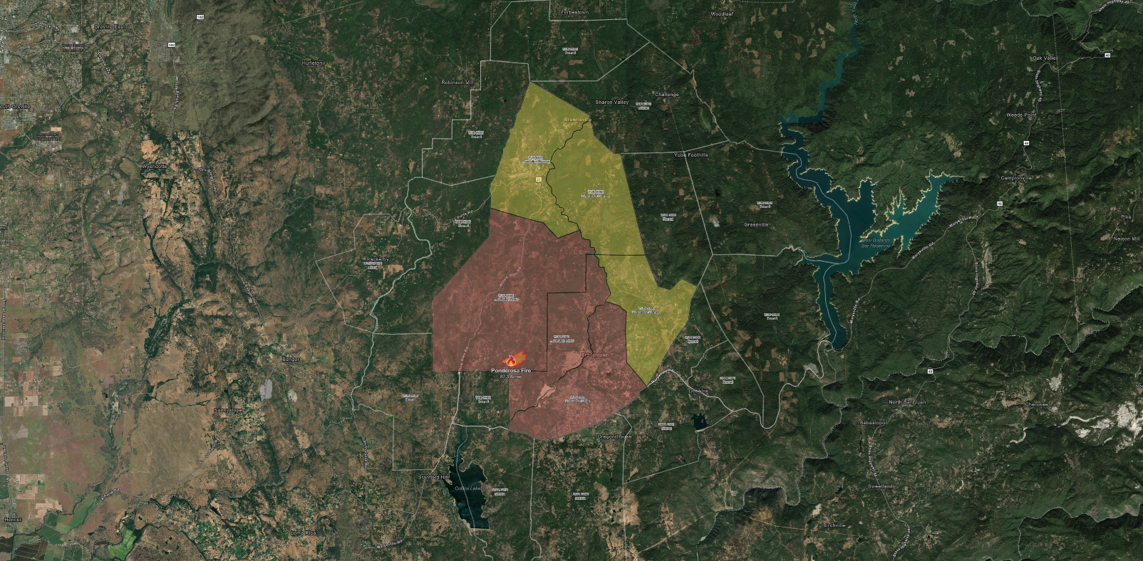
The Ponderosa Fire has burned 87 acres in Yuba County since it began on the morning of Sunday, August 10th, with zero containment in the latest CAL FIRE report. Officials say the wildfire is spreading at a dangerous rate along Ponderosa Way north of Sunset Road in Oregon House.
6:55pm update: 83 acres and 0% contained.
— CAL FIRE Nevada-Yuba-Placer Unit (@CALFIRENEU) August 11, 2025
4:42pm update: PonderosaFire, 48 Acres. Ponderosa Way North of Sunset Road, Oregon House. Dangerous rate of spread.
4:12pm update: additional resources requested. Dangerous rate of spread. Structures threatened. pic.twitter.com/OBH46UzLFf
The cause of the fire remains under investigation. CAL FIRE’s Nevada-Yuba-Placer Unit is leading incident management.
Mandatory evacuation orders in effect:
Evacuation orders—defined as an immediate threat to life—have been issued for the following Yuba County zones. Residents in these areas must leave immediately:
- YUB-E094
- YUB-E093
- YUB-E089
Evacuation warnings: Be ready to leave
Evacuation warnings are in effect for nearby zones where fire activity could increase. Those needing extra time to evacuate, including households with pets, livestock, or mobility concerns, are strongly advised to relocate now:
- YUB-E081
- YUB-E092
- YUB-E006
Real-time Ponderosa fire perimeter map:
Residents can track active fire conditions, thermal hotspots, and smoke movement via interactive satellite and perimeter maps from sources like CAL FIRE’s official incident page.
For a real-time view of satellite activity over the Ponderosa Fire area, use the interactive map below. This NOAA-based RealEarth tool shows live fire perimeters, thermal hotspots, smoke coverage, and surface observations across Oregon House and the surrounding Yuba County region.
Fire behavior and containment outlook:
From 48 acres at 4:42 p.m. Sunday, the Ponderosa Fire grew to 83 acres by 6:55 p.m., and 87 acres by 8:05 p.m., underscoring the dangerous rate of spread. Containment remains at 0%, and with continued dry conditions, officials warn that the fire could grow further overnight.
Ponderosa Fire among California’s active wildfires:
The Ponderosa Fire, at 87 acres with zero containment, is far smaller than the Gifford Fire in San Luis Obispo and Santa Barbara counties—which at more than 118,000 acres is California’s largest active blaze—but remains a priority in Yuba County.
Below are the 10 largest active wildfires in California, with acreage and containment levels reported Sunday evening:
| Fire | Counties | Acres | Containment |
|---|---|---|---|
| Gifford Fire | San Luis Obispo, Santa Barbara | 118,068 | 33% |
| Orleans Complex | Del Norte, Siskiyou | 22,117 | 81% |
| Green Fire | Shasta | 19,022 | 99% |
| Canyon Fire | Los Angeles, Ventura | 5,370 | 78% |
| Rosa Fire | Riverside | 1,671 | 90% |
| Gold Fire | San Bernardino | 1,079 | 47% |
| Panoche Fire | San Benito | 423 | 75% |
| Richbar Fire | Kern | 120 | 25% |
| Tiger Fire | Amador | 118 | 25% |
| Ponderosa Fire | Yuba | 87 | 0% |
Safety guidance:
Authorities emphasize the following:
- Leave immediately if under an evacuation order
- Keep pets and livestock ready for quick transport
- Avoid approaching fire zones to photograph or film
- Follow only verified sources such as CAL FIRE and county emergency services
There is currently no timeline for containment, and conditions remain hazardous in the Oregon House area. Residents should remain alert for changing evacuation statuses.


