LA wildfires: Containment progress and damage update
Daily wildfire updates: Los Angeles County faces 105 active fires, 40,306 acres burned, and ongoing containment efforts as of Monday, 1/13/25.


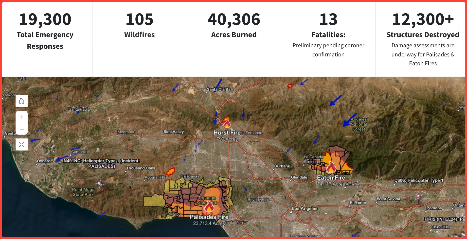
The California Department of Forestry and Fire Protection (CAL FIRE) released an updated report early Monday morning highlighting the devastation caused by ongoing wildfires in Los Angeles County. The latest figures, as of 5:00 AM PT, reveal a significant toll on the region's landscapes, structures, and lives.
Key Statistics:
- Total Emergency Responses: 19,300
- Active Wildfires: 105
- Acres Burned: 40,306
- Fatalities: 13 (pending coroner confirmation)
- Structures Destroyed: 12,300+ (Damage assessments are underway for the Palisades and Eaton Fires.)
Wildfire Overview:
CAL FIRE's interactive map shows a concentration of large-scale fires impacting Los Angeles County. Three major incidents currently dominate the landscape:
1. Palisades Fire
- Location: Los Angeles County
- Acreage: 23,713 acres burned
- Containment: 13%
- Start Date: January 7, 2025
The Palisades Fire is the largest active blaze in the region, rapidly consuming land and threatening nearby communities. Emergency crews are working around the clock to establish containment lines.
2. Eaton Fire
- Location: Los Angeles County
- Acreage: 14,117 acres burned
- Containment: 27%
- Start Date: January 7, 2025
The Eaton Fire has destroyed thousands of acres and prompted evacuation orders for residents in its path. Firefighters have made some progress, reaching over a quarter of containment.
3. Hurst Fire
- Location: Los Angeles County
- Acreage: 799 acres burned
- Containment: 89%
- Start Date: January 7, 2025
The Hurst Fire is nearing full containment, thanks to extensive efforts by CAL FIRE and local responders.
Ongoing Challenges:
The interactive map also highlights significant environmental conditions complicating firefighting efforts, including:
- High Wind Activity: Pockets of wind activity, mapped in blue arrows, continue to fan flames.
- Smoke and Haze: Thick layers of smoke reduce visibility and air quality, impacting firefighting operations.
- Red Flag Warnings: The risk of further ignitions remains elevated due to dry conditions and high winds.
CAL FIRE reminds residents to stay vigilant, adhere to evacuation orders, and monitor updates through official channels. The agency is actively assessing the damage to structures and will continue providing updates as the situation evolves.
For the latest information on evacuation orders, air quality, and firefighting efforts, visit the CAL FIRE website.
You can als0 check our regional CA forecasts to learn about conditions in nearby regions:
Related Coverage from Californiatoday.com:
- Viral Instagram posts capture the LA Fires' devastation
- CA wildfire update (1/9/25): Palisades and Eaton Fires leave devastation in LA County
- Wildfires devastate Los Angeles County: Update, Wednesday 1/8/25
- National Weather Service issues warnings for Ventura County through 1/8/25: What residents need to know


