Powerful winter storm to bring Sierra snow, severe weather, and fire danger across US
A major winter storm is sweeping across the central U.S., bringing blizzard conditions, severe thunderstorms, and fire weather risks.


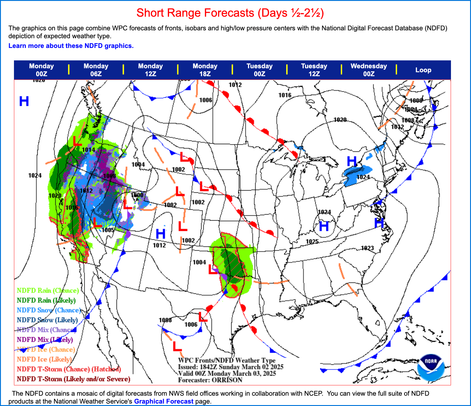
March 2, 2025 – A rapidly intensifying winter storm moving through the central United States will bring a mix of hazardous conditions, including blizzard conditions, severe thunderstorms, and fire weather risks, according to the latest forecast from the National Weather Service (NWS). California is also feeling the storm’s effects, with rain impacting lower elevations and heavy snowfall expected in the Sierra Nevada.
Blizzard Conditions and Heavy Snow from the Rockies to the Midwest
A powerful low-pressure system currently tracking eastward from the Intermountain Region is expected to strengthen significantly by Monday night as it moves into the central High Plains. This storm will bring substantial snowfall to the western mountains before shifting eastward, where it will produce a swath of heavy snow and strong winds from the central High Plains to the Upper Midwest through midweek.
- California & Western U.S.: The Sierra Nevada is expected to receive 6 to 12 inches of new snowfall, with the central Rockies and Great Basin seeing totals of 1 to 2 feet by Tuesday. Lower elevations in Northern California will see rain showers and gusty winds, but no major flooding concerns at this time.
- Central High Plains to Upper Midwest: The system will bring 4 to 8 inches of snow, with some areas in the Upper Midwest potentially receiving a foot of accumulation. Strong winds will create blizzard conditions, leading to dangerous travel disruptions.

Severe Weather Threat for the Southern Plains and Lower Mississippi Valley
As the storm system moves east, it will interact with warm, moisture-rich air from the Gulf of Mexico, fueling severe thunderstorms across the southern Plains and Lower Mississippi Valley.
- Monday: Heavy showers and thunderstorms will develop across the southern Plains, including the Red River Valley.
- Tuesday: A major severe weather outbreak is expected, with the greatest risk in the Lower Mississippi Valley and Mid-South region. The Storm Prediction Center has issued an Enhanced Risk (Level 3 of 5) for severe storms in these areas.
- Threats: Strong damaging winds, large hail, and the potential for tornadoes will be the primary hazards. Flash flooding is also possible, with a Slight Risk (Level 2 of 4) for excessive rainfall in the Midwest and Lower Mississippi Valley.
Extreme Fire Danger for the Southern High Plains
In addition to winter and severe weather, extreme fire conditions are expected across portions of the southern High Plains.
- Affected Areas: New Mexico, southeastern Colorado, southwest Kansas, western Oklahoma, and western Texas.
- Hazards: Strong winds, low humidity, and dry conditions will create critical to extreme fire weather danger Monday through Wednesday.
Temperature Swings Across the Country
The storm will bring dramatic temperature fluctuations, with much above-normal temperatures spreading from the Midwest into the Eastern U.S. by Tuesday and Wednesday. Meanwhile, colder air behind the system will bring below-normal temperatures to the western U.S. before pushing into the central Plains. In California, temperatures will remain near seasonal averages, though the Sierra snowfall will contribute to cooler conditions in the interior.
What to Expect Next
This dynamic storm system will continue to evolve in the coming days, bringing widespread impacts across the country. Travelers and residents in affected areas should stay updated on forecasts, take precautions, and prepare for potential power outages, hazardous roads, and severe weather conditions.
In California, motorists heading into the Sierra should prepare for difficult travel conditions due to accumulating snow and strong winds, with possible chain controls in effect on major mountain passes.
For real-time updates, visit the National Weather Service or tune in to local advisories.


