

Power line equipment has burned 1.49 million acres in CA since 2000—State records show PG&E responsible for 86%
Our analysis of CAL FIRE's complete historical fire record finds a decade-long pattern of electrical infrastructure igniting some of the state's worst disasters—concentrated in one utility's service area.


In November 2018, a PG&E transmission line in Butte County failed before dawn. Within hours, the Camp Fire had overrun the town of Paradise, killed 85 people, and become the deadliest wildfire in California history. Three years later, PG&E equipment in Plumas County started the Dixie Fire—which burned for 104 days and scorched 963,405 acres, the largest single wildfire in state history. In between, in 2019, a PG&E transmission tower in Sonoma County sparked the Kincade Fire, forcing the evacuation of nearly 200,000 people.
These are not isolated incidents. They are part of a pattern that runs through 25 years of California state wildfire data.
Our analysis of CAL FIRE's complete historical fire perimeter database—covering every recorded wildfire from 1878 to 2025—found power lines were the documented cause of at least 419 wildfires since 2000, burning a combined 1.49 million acres across 51 of California's 58 counties.
419 Wildfires Started by Power Lines Since 2000
1.5 million acres burned — mapped by county and utility territory
Roughly 60 percent of those fires started within Pacific Gas & Electric's service territory. In addition, PG&E territory makes up 86 percent of the total acreage burned in power line fires statewide—1.29 million acres.
Southern California Edison, which serves most of inland Southern California, accounts for another 21 percent of fires, including the 2018 Woolsey Fire, which burned nearly 90,000 acres in Los Angeles and Ventura counties and destroyed more than 1,600 structures. San Diego Gas and Electric, accounts for 2.6 percent.
Sources & Methodology
The fire count and acreage figures in this story come from the CAL FIRE Historical Fire Perimeters dataset (firep25_1), the official record of California wildfire perimeters maintained by CAL FIRE's Fire and Resource Assessment Program (FRAP). The version used here was released in April 2026 and includes 516 fires from the 2025 fire season. It covers fires going back to 1878, developed in cooperation with the USDA Forest Service Region 5, the Bureau of Land Management, California State Parks, the National Park Service, and the U.S. Fish and Wildlife Service.
We filtered for fires with cause code 11 (Power Line) and an ignition year of 2000 or later. The dataset only includes fires meeting minimum reporting thresholds — at least 10 acres in timber, 50 acres in brush, or 300 acres in grass, or causing at least three structure impacts or one fatality — which means smaller power line fires are not captured. The 419 figure is a floor, not a ceiling.
County assignments were made by spatial analysis: we matched each fire's polygon centroid to California county boundaries using a geographic intersection, with a nearest-neighbor fallback for edge cases. All 419 fires were successfully assigned. Utility territory assignments are based on published CPUC investor-owned utility service areas, applied at the county level. Counties that straddle two territories — Los Angeles (LADWP within the city, SCE surrounding) and San Luis Obispo (PG&E north, SCE south) — use combined designations. Acreage is GIS-calculated from polygon geometry and may differ slightly from official incident reports.
The Tubbs Fire (2017) is not in the 419 count. CAL FIRE determined in January 2019 that the fire originated from a privately owned electrical system, not PG&E infrastructure, and coded it as Unknown cause. The finding has been contested in civil litigation.
For PG&E's legal history, we relied on CBS News reporting on the 2020 guilty plea, the Sonoma County District Attorney's statement on the Kincade Fire resolution, and KQED's coverage of PG&E's 2020 bankruptcy exit. All data and code used in this analysis are available on request.
A Problem That Has Gotten Larger, Not Smaller
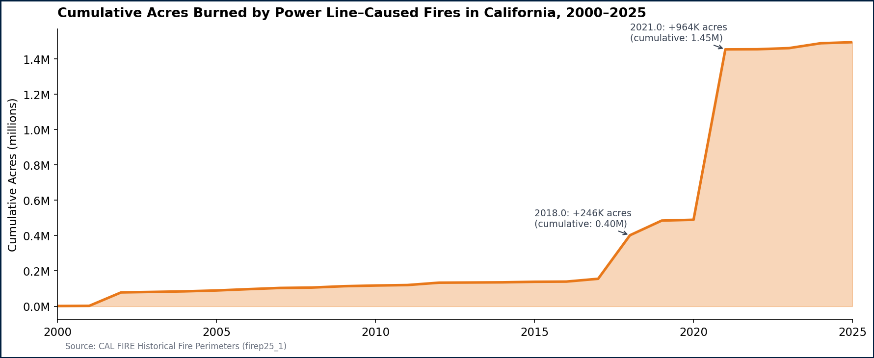
The raw count has remained stubbornly consistent—between 8 and 41 fires per year since 2000, with no clear downward trend. But the acreage has become dramatically more extreme. The 2018 and 2021 fire seasons alone account for more than 1.1 million of the 1.49 million total acres burned—nearly three-quarters of the 25-year toll in just two years.
2020 saw the highest single-year fire count in the dataset: 41 power line fires. The year was already catastrophic for California fire overall; power line ignitions added to a season that burned more than four million acres in total from all causes.
The cumulative toll tells the starkest story. It took 17 years—from 2000 through 2017—for power line fires to accumulate their first 200,000 acres. Then came 2018 with the Camp Fire, followed in 2021 by the record setting Dixie Fire. By the end of 2021, the cumulative total had crossed one million acres. It now stands at at almost one and a half million.
The Geography of Risk
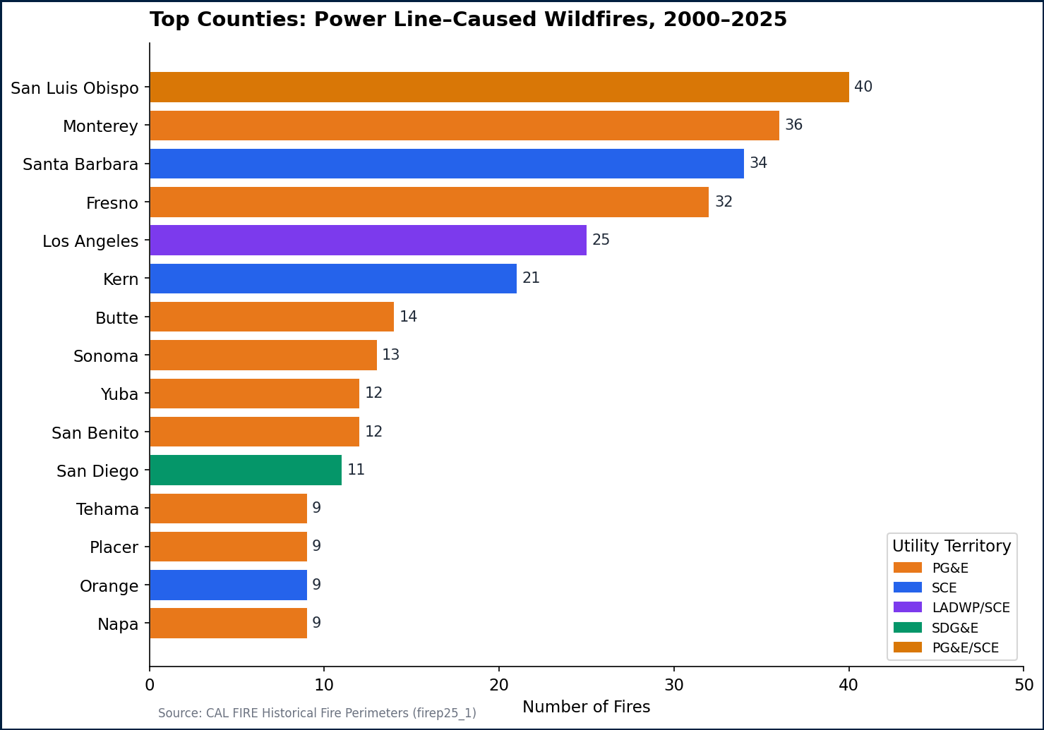
The fires are not evenly distributed across the state. San Luis Obispo County has seen the most power line fires of any county—40 since 2000—followed by Monterey (36), Santa Barbara (34), and Fresno (32). But fire count alone understates the risk. Butte County, site of the Camp Fire, has seen a relatively low 14 power line fires, but they burned a total of 163,761 acres—more than in any county except Plumas, where the Dixie Fire alone accounts for 963,405 acres.
The concentration of major fires in PG&E's service area reflects both geography and infrastructure age. PG&E operates one of the largest electric transmission and distribution systems in the country—more than 100,000 miles of lines across Northern and Central California, much of it running through fire-prone terrain in the Sierra Nevada foothills, the Coast Ranges, and the Central Valley's eastern edge.
How the Utilities Compare
PG&E's dominance in these numbers is not simply a function of serving a larger territory. Edison (SCE) serves a population comparable in size—roughly 15 million customers versus PG&E's 16 million—but Edison's territory accounts for 21 percent of fires and a far smaller share of acres burned. SDG&E, despite operating in some of Southern California's most fire-prone coastal terrain, accounts for just 11 fires and 62,322 acres over the 25-year period.
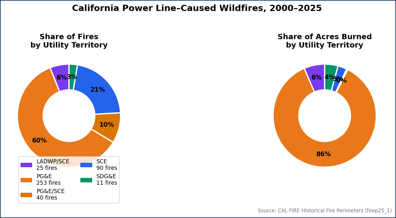
The disparity in acreage is partly structural—PG&E's service area includes more remote, heavily forested terrain where fires can run unchecked—but it also reflects the specific catastrophic scale of a handful of fires that started with a single failed component on PG&E's system.
PG&E pleaded guilty in 2020 to 84 counts of involuntary manslaughter related to the Camp Fire, and admitted its equipment caused the Kincade Fire. The company emerged from bankruptcy in 2020 after paying billions in settlement funds to fire victims. It has since invested in grid hardening—replacing overhead lines, installing sectionalizing devices, and implementing public safety power shutoffs—but environmental and safety advocates have questioned whether those measures are sufficient given the pace of infrastructure aging and climate-driven fire risk.
What the Data Doesn't Show
The 419 fires in this analysis are almost certainly an undercount. CAL FIRE's database codes fires by cause, but determination of cause can take months and is sometimes never resolved. More than 10,000 fires in the full historical database are coded as Unknown or Unidentified cause—some of which were likely started by power infrastructure.
The Tubbs Fire—which burned 36,702 acres and destroyed much of the Coffey Park neighborhood in Santa Rosa in October 2017—is not included in this analysis. It is coded in CAL FIRE's database as cause Unknown. CAL FIRE ultimately concluded the fire was ignited by a privately owned electrical system, not PG&E's lines, and cleared the utility—a finding that remains contested. The Tubbs Fire alone would add 36,702 acres to the tally if included.
The figures here represent the documented floor of a problem that official investigations suggest is larger in reality.


